Here's one free chapter from my book, including the actual photographs and the map that appears in the book. This chapter covers the beaches in the Venice, Florida area. The book has 34 chapters.
Venice
Interstate 75 Exit: 193 (Jacaranda Blvd)
Nearest mainland city: Venice beaches are mainland beaches in the city of Venice.
Major access roads: Jacaranda Blvd, Venice Avenue.
Directions: Venice is located 15 minutes south of Sarasota and Nokomis on US 41. From I-75, take the Jacaranda exit #193 and follow Jacaranda Blvd. to Venice Avenue. Venice Avenue will take you right through downtown Venice and straight to Venice Municipal Beach.
Entrance fee: All beaches are free and all parking is free.
Hours: Beaches and parks are open from 6 am to midnight every day, except Paw Park which is open from 7 am until dusk.
Pets: Pets are not allowed on the beaches, except at Paws Park just south of the Venice fishing pier. Service dogs are generally permitted.
Disabled Access: Venice Municipal Beach, Brohard Park (by the pier), and Caspersen Beach have restrooms that are ADA compliant, and provide boardwalks with ramps to the beach. However, at the time of this writing, only Venice Municipal Beach offers beach wheelchairs.
Restrooms: All public beach parks provide restrooms.
Food and Drink: Venice Municipal Beach, Humphris Park (at the jetty), and Sharky’s Restaurant at the Venice Fishing Pier all provide food and drink on the beach. There are plenty of restaurants on Venice Avenue off U.S. 41, just a few blocks from the beach.
Alcohol: Alcoholic beverages are allowed on the beach. Glass containers are not allowed on the beach.
Shelling: The Venice beaches have a selection of shells that ranges from average to very good. Shark teeth and other fossils are found on the beaches and in the water.
Lifeguards: Venice Municipal Beach offers lifeguards year-round during posted hours.
Weddings: Venice Beach is an excellent location for beach weddings.
Camping: There are no opportunities for camping on Venice beaches.
70: Venice Municipal Beach
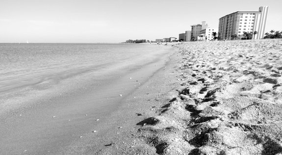
(GPS: 27.10046, -82.459748). 101 The Esplanade, Venice, FL. Take Venice Avenue as far west as you can and you will see Venice Municipal Beach right in front of you. The street that runs north and south along the Gulf is called The Esplanade. Venice Beach has lifeguards on duty during posted hours, and a beach pavilion with a striking winged design houses a food concession and restrooms. Venice Beach is a great spot to find fossilized shark teeth. Look for them down by the water’s edge. As Sanibel Island is famous for its shells, Venice is famous for its shark teeth. You will see many people sifting through the sand in search of the dark colored teeth. Because of the heavy fossil deposits located just offshore, Venice has a natural black sand beach. It isn't really all black, but it is very dark because of all the tiny pieces of fossils mixed in with the sand. The offshore fossil deposits attract SCUBA divers who are able to collect the fossils before they are worn down by wave action on the beach. The really big shark teeth are found off the beach in about 15 to 20 feet of water.
In April each year, Venice hosts the Shark Tooth Festival on the airport grounds not far from the beach. It draws quite a crowd. You can see, touch and buy shark teeth and fossils of all kinds. Visit their web site at sharkstoothfest.com. When sand is added to the beaches during infrequent beach renourishment projects, large sections of the black sand beach may be covered with lighter colored sand, but the fossils still can be found at the water’s edge and in the water. Hunting for shark's teeth along the Venice beaches is so popular that local sporting goods stores sell special scoops—sometimes referred to as “Florida snow shovels”—for sifting the sand. In a few hours of collecting, anyone can find hundreds of teeth and other fossils. Venice beach is flanked by condominiums which house a large retirement population. The city attracts quite a few European visitors, and it is not unusual to hear Italian being spoken on the beach. Many of the street names are Italian. Venice, Florida refers to itself as the “sister city” of Venice, Italy.
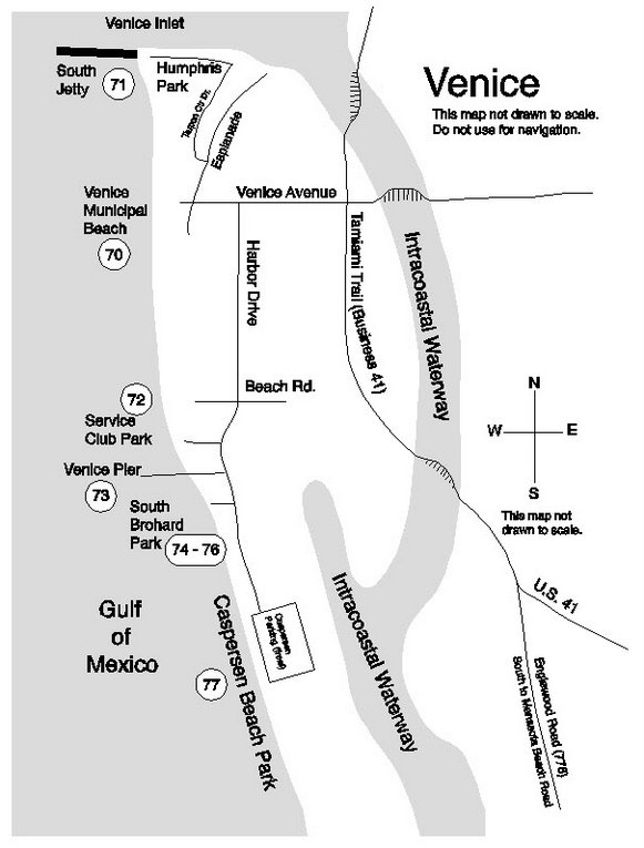
Note: The actual map images in the book are of a much higher quality than the example map above.
71: South Jetty (Humphris Park)
GPS: 27.11233, -82.46663). 2000 Tarpon Center Drive, Venice, FL. Follow The Esplanade north to Tarpon Center Drive. Turn left on Tarpon Center Drive and follow it to its natural end at the Venice Inlet and the south jetty, officially named Humphris Park. Popular with fishermen all year, this jetty is one of the best surfing spots on the west coast on a north or west swell, which usually happens during winter cold fronts. The park is nearly surrounded by water, with the Gulf on the west and south side, and the inlet on the north side. From south jetty you can access the beach, but this is really more of fishing or surfing spot than a beach. A short trail leads to the beach, passing under some Australian pines with some very healthy prickly pear cactus as ground cover. The beach here is fairly steep and is dominated by condominiums. The beach crowd is mostly retirees, except when the surf is up and surfers come from all over to catch waves. From south jetty you can walk to any beach in Venice if you are a serious beach walker. Walk all the way out to the end of the jetty and you’ll have a great view of the coast.
The park’s concession sits just feet from Venice Inlet and is a popular place to hang out and grab a bite to eat, or just sit with a cup of coffee and enjoy the view. It also provides public restrooms.
There is no lifeguard on duty at Humphris Park. There is plenty of free parking, except when the surf is up and surfers and their vehicles arrive from all over the state. The unpaved parking lot is closed to vehicles from midnight to 6 am. Camping is not allowed. No animals are allowed in the park or on the beach and no fires are permitted in the park.
Brohard Park Area
Brohard Park encompasses 67 acres of beachfront parks on Harbor Drive, south of Beach Road. It includes Service Club Park, Venice Fishing Pier, Maxine Barritt Park, and South Brohard Beach. Descriptions of each beach access follow.
72: Service Club Park
(GPS: 27.07869, -82.45083). 1190 S. Harbor Drive, Venice, FL. From Venice Avenue, go south on Harbor Drive. After driving a mile or so, you’ll see a sign pointing the way to the beaches. Service Club Park is easily overlooked. It's on the right and is marked by a sign. It has restroom facilities, covered picnic tables, and some limited playground equipment for small children. The restrooms and the boardwalk, including the picnic tables, are wheelchair accessible, but to get down to the sandy beach requires descending about a dozen wooden steps.
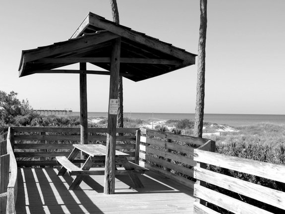
Photo: Picnic tables on the boardwalk, Service Club Park.
The park has no food concession and no lifeguard. The parking area is paved, but is not very large. The area between the parking lot and the beach is very thickly wooded with saw palmettos and pine trees. A 350-foot long boardwalk leads from the parking area to the beach through an area thickly wooded with saw palmetto and pine trees. Also situated on the boardwalk are several covered picnic tables.
You can walk south on the beach to Brohard Park and the Venice Fishing Pier in just a few minutes. This is a favorite fossil hunting place for some people. I've seen people create some very interesting devices for separating fossils from sand and shells using some type of wood or metal frame and various types of screens. Some people buy and sell shark’s teeth in quantity. It is not unusual to see SCUBA divers entering the water here to search for fossils offshore.
Service Club Park is gated, and it closes between midnight and 6 am. RV’s over 20 feet in length are not allowed in the park. Alcoholic beverages are allowed in the park, but glass containers are not.
A word of caution: There are a number of ditches, ponds and low-lying areas near the Venice beaches south of the pier. Alligators do live in those wet areas.
73: Venice Fishing Pier / Brohard Park
(GPS: 27.07428, -82.45020). Continuing south on Harbor Drive, past Service Club Park you will see the sign at Sharky's Restaurant. Sharky’s is a nice place to eat while listening to tropical music and gazing upon the water and the fishing pier. You can eat on the deck or inside. It's a bit pricey though, even for a hotdog. But it’s right on the beach, what do you expect? There is an outdoor deck, including an upper level, which is great for cooling off in the afternoon sea breeze. Get more info at www.SharkysOnThePier.com . Parking and beach access are free. The beach near the pier is great and has the dark sand characteristic of Venice beaches. The water is usually a chalky green near shore, but is clearer further out.
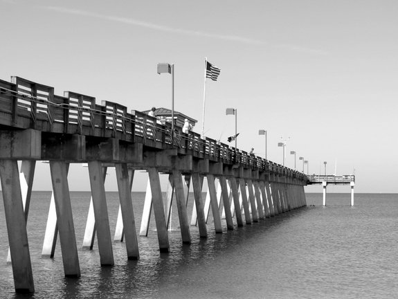
Photo: Venice Fishing Pier.
Some very serious fishing takes place on the 700 foot long Venice fishing pier. Papa’s Bait and Snack Shop located out on the pier keeps the fishermen well-supplied from 6 am to 9pm. There is no fee to access the pier which is open 24 hours a day every day of the year, though the beach park is closed from midnight to 6 am. You can rent fishing gear if you need to (or rent a Florida snow shovel to sift the sand for shark teeth). No fishing license is needed to fish from the pier, but if you want to fish from the beach, you’ll need a Florida saltwater fishing license. The pier was originally built in 1966 and has been rebuilt twice since then (1984 and 2004). The pier makes a great foreground for sunset photographs. Get more info at www.VeniceFishingPier.com .
Here’s a tip for the penny pinchers: A cheeseburger with fries at Sharky’s is $10.50; a cheeseburger at Papa’s Bait shop on the pier is $3.50.
The Brohard Park public beach facilities are just north of the pier and share the same access driveway. The restrooms are new and modern and are ADA compliant. Outdoor rinse-off showers are provided. There is no picnic area, but there are several covered picnic tables at the pavilion overlooking the dune and beach. RV’s are not allowed in Brohard Park’s parking lot.
74: Maxine Barritt Park
(GPS: 27.07141, -82.44808). 1800 S. Harbor Drive, Venice, FL. This is a relatively new park situated immediately to the south of the Venice fishing pier. It is a nice park, with its own lake and lots of sidewalks and a few covered picnic tables. Clean, modern restrooms and a large picnic pavilion offer great facilities for gatherings, but it is not a good beach access point. Though the park has 1400 feet of beautiful beachfront, the only two access points are at the north end by the pier, and at the south end via the dog park. There are several beach overlooks on the boardwalk, but they do not provide for beach access. The parking area is separated from the beach by the lake, so the shortest distance from the parking area to the beach at the north end of the park is about 800 feet. At the south end the beach is accessed by entering the dog park. Essentially, the south end of Maxine Barrett Park functions as overflow parking and restroom facilities for Paw Park. There is no food concession and no lifeguard.
If you’d like to stop and do a little birdwatching, the lake attracts quite a few water birds. The sidewalk which circumnavigates the lake offers a meandering walk for a distance of two-thirds of a mile, nearly half of which is just behind the dunes and offers several overlooks to stop and enjoy the view of the beach and Gulf.
75: Paw Park at Brohard Beach
(GPS: 27.06971, -82.44703). 1600 Harbor Drive S., Venice, FL. This is the best dog beach park on the peninsular west coast of Florida. It is rivaled only by the dog park at Fort Desoto County Park in Pinellas County, and I suppose one could argue about which is superior. The fenced park has a place to rinse off your dog, a picnic shelter with tables, and a path to the Gulf beach. Entrances and exits from the fenced area are double-gated. Dogs are allowed in a restricted area on the Gulf beach and are not required to be leashed. The Gulf is about 700 feet from the fence area with drinking water, so consider taking some drinking water out onto the beach for your dog. Swimming in the salt water will make them thirsty. The park is open from 7 am to dusk.
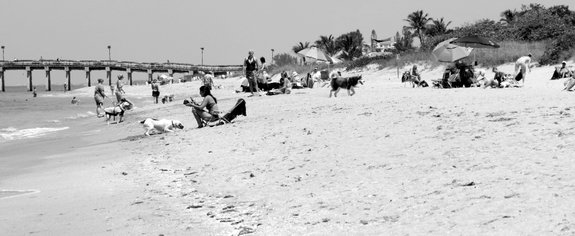
Photo: Paw Park, south of the Venice Fishing Pier is one of the best dog beaches in Florida.
76: South Brohard Park
(GPS: 27.06694, -82.44714). Just around the corner from Paws Park, this park provides a large paved parking area, restrooms, and two boardwalk trails to the beach. There are no food concessions or lifeguards. This access is good for people who don’t want to hang out by the pier or drive down to Caspersen beach, but it is just a few hundred feet from the dog beach, for those concerned about dogs running loose. The parking lot is rarely full, and you could most likely find a spot for an RV around the edges of the lot. The restroom has a ramped entry and one of the dune crossover boardwalks is wheelchair accessible. If you just want easy beach access and want to avoid the crowd around the pier, this is an excellent access.
77: Caspersen Beach Park
(GPS: 27.05647, -82.44262). 4100 Harbor Drive South, Englewood, FL. From South Brohard Park, Harbor Drive follows the coast south for half-a-mile, just behind sand dunes that spill onto the roadway. It ends at a large parking area with restroom facilities. This is Caspersen Beach Park. The park has an extensive 1,400 foot boardwalk system providing access to the beach. The beach in front of the boardwalk is rocky, with areas of soft sand. At the south end of the boardwalk the rocks give way to nearly two miles of soft sandy beach in varying shades of gray and near-black.
With major improvements to all of Venice’s beach facilities in recent years and with the continued promotion of the area, this is not the remote and quiet park it used to be. Weekdays during the summer months are the least crowded time to visit, but you can usually find a quiet spot by walking south on the beach any time of year.
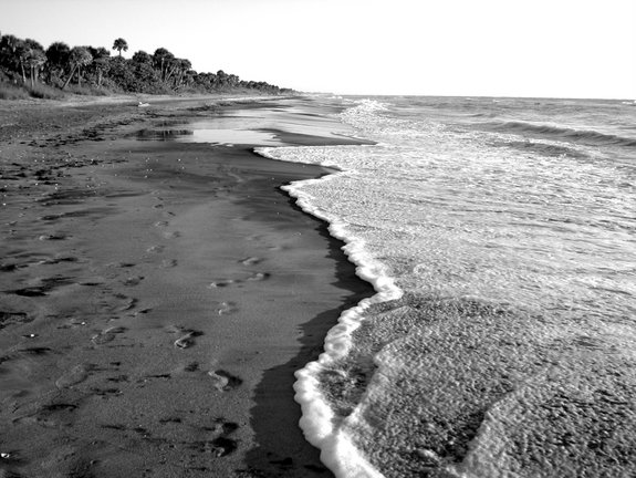
Photo: Caspersen’s “black” sand beach, looking south toward Manasota Key.
Since this beach is located so close to Venice Airport you will discover that there always seems to be an airplane within ear shot. No jets; just the sometimes annoying buzz of small single propeller aircraft. After a while you get used to it. If you’re shooting video on the beach, the plane noise always seems to end up in the audio.
In 2011/2012 Caspersen Beach Park facilities were renovated in a big way. The new restroom facilities have larger restrooms and a separate family restroom. The restroom facilities are ADA compliant. Access to the facilities is made easier with paved parking spaces and sidewalks, and sloped entry ramps with grab rails. There is a handicap access dune crossover with ramps near the handicap parking and restrooms, although there is not, as of this writing, a beach wheelchair available to get you across the sand to the water’s edge.
The system of boardwalks along the beach has been greatly improved and enhanced. The boardwalk meanders along 1,400 feet of the beach through vegetation, past numerous stair cases or ramps to the beach. This is one of the most scenic beach boardwalks in Florida. The beach is very rocky in front of the boardwalk and is an excellent place to look for shells, shark teeth and other fossils. When the water is clear and calm, it is also an excellent place for snorkeling. There are five rocky reefs just 50 feet or so off the beach extending as far as 150 feet from shore. The northern segment of the boardwalk has handicap parking spaces right next to the boardwalk to minimize the distance to the beach.
The bay side of the park now has restrooms, a large covered picnic pavilion and children’s playground, and a kayak launch area. Caspersen Beach Park is a trailhead on the Venetian Waterway Park paved multi-use trail, which begins at the Venice Train Depot and runs south along each side of the Intracoastal Waterway. The western trail terminates at Caspersen Beach. So you can bring your bike along to do some trail riding. The trail also connects to Venice’s Legacy Trail, which runs north from the Venice Train Depot.
Harbor Drive is closed to traffic about 500 feet from where it dead-ends at the beach. The last 500 feet of roadway make a great walking or bike path toward the quieter parts of this beach. At the southern end of Harbor Drive, as far as the eye can see there is nothing but water, sand, and trees. The completely undeveloped portion of the beach continues south for nearly two miles before you start seeing houses on the beach. So if you are planning to take a lengthy stroll along the beach, or to explore the trails in the woods above the beach during the warmer months, I strongly urge you to carry plenty of cold water. Insects are not usually a problem, but on very still, humid summer days the no-see-ums and biting flies can sometimes be bothersome until the afternoon sea breeze kicks in.
Caspersen Beach has a sand bluff above the beach leading to a very large wooded area crossed with walking trails. There are no homes or buildings of any kind along the park’s shoreline. Consequently, wildlife is abundant. There are gopher tortoises in the woods and the beach is strewn with raccoon footprints. In the early summer, beginning in May, you can see lots of sea turtle tracks and nests on Caspersen beach. The turtles come out of the Gulf at night and crawl up the beach, leaving bulldozer-like tracks behind them. They dig a large hole, lay their eggs, and cover the hole before heading for the water again. So they leave two tracks--one coming and one going--leaving the impression of a bulldozer coming up out of the water.
Caspersen Beach is a great place to look for shells, and a great variety of sea life washes up on the beach. Various sea grasses, sponges, corals, bones, carcasses, fossils, fishing floats, ropes, you name it. Don't miss it. Bring your fishing pole, a shell rake, a cooler, a beach tent, a kayak, a ball, a Frisbee, a kite, whatever. Spend the whole day. If you want to get away from the crowd, quiet portions of the beach are just a short walk away.
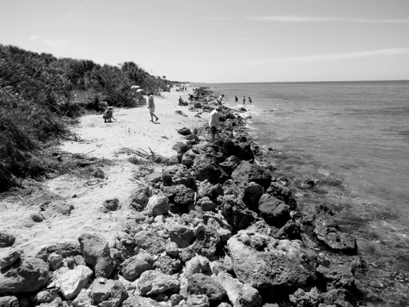
Photo: Rocky area off Caspersen beach is suitable for snorkeling.
On a final note, I feel I must mention that because of its secluded—bordering on remote—location, Caspersen Beach attracts some folks who want to engage in certain activities in a natural environment. To be blunt, in addition to attracting a contingent of benign and discrete naturists (nudists) who discretely use the southern remote areas of the park, Caspersen Beach has a well-documented problem of certain gay men hanging around trying to hook-up with other men, sometimes exposing themselves inappropriately and engaging in sex acts in the woods above the beach and on the beach in some not-so-secluded areas.
Most beachcombers agree that we should not allow this situation to keep us from enjoying this wonderful beach. If you see inappropriate behavior, report it to the Sherriff’s Department. Just to be clear, I do not conflate discrete nudity on a remote beach with inappropriate public sexual activity. They are two completely separate issues.
There are many families that bring their children here and enjoy the beach near the boardwalk and parking area and never have a problem. On weekends and holidays when there are plenty of people around, you are much less likely to encounter inappropriate behaviors. However, if you come to Caspersen Beach during the week, especially earlier in the morning or later in the afternoon and evening, your chances of encountering inappropriate behavior are increased, especially if you walk south for half a mile on the deserted beach or go into the woods above the beach. It goes without saying that children should not play unsupervised in the wooded or remote areas, which is good advice for any location.
Click Here to Buy the Book Now from Amazon.com!